November 10 - 11, 2013


I first saw this lonely mountain at the center of when I went to Baguio last Nov.01 - Nov.04, 2013. And then for some reason I felt the need to climb this mountain, the view up there with the wide plains must be refreshing. And just after a few days of work here I am waking up early for our weekend climb. My climbing buddies were Engle and his friend from college, Justine. It was Justine's 1st time to climb a mountain so we decided to just lighten the pace of the climb.
- 05:00 We met at Victory Liner Terminal - Cubao and ate at a nearby restaurant before buying our ticket for 102.00 php. We rode the bus bound for Olongapo. There were only a few passengers and we were not able to catch the 05:00 bus so we ended up departing 06:00 in the morning. The bus ride only took about an hour and our group alighted the bus at Robinsons Starmills near SM Pampanga, there are 3 SM malls in the province (SM Pampanga, SM San Fernando, and SM Clark).
- 07:00 After the bus ride we rode a jeep going to Arayat for 20.00 php each. We had some jolly girls with us at the jeep that giggled at the sight of Justine and jokingly tells the driver to step on the break hard so they can hug him. Luckily they were friendly and taught us how to get to the Magalang Trail.
- 07:20 After alighting at Bayan we walked a few blocks to a terminal going to Magalang Municipal Hall. The fare was 27.00 php each, and it was another long jeep ride so I took a nap.
- 07:45 Touchdown at Magalang Municipal Hall, landmark is a Jollibee branch at the corner. After drinking coffee at Jollibee we got into one of the tricycles lined up just outside Jollibee to take us to the registration area for climbers. Fare up to the registration area is 100.00 php (Good for 3 persons).
- 08:10 We alighted at the start of the "Stations of the Cross", just so I can take pictures of the stations while going up. To our surprise, there was no registration at that area and we decided to just climb until we see the DENR Information Center and register there, you should register or no one will know if something happens to you at the mountain and you weren't able to get down. The 1st station was located just beside the road, and the concrete road continued up to the 4th station then it was rugged road all the way up to the 1st registration area.
A Station of the Cross
- 08:20 At the registration area we asked the kind people stationed if we can climb the mountain with no guide. They just told us as long as we know the trail and are not 1st time climbers we can, the golden rule they gave us was just to follow the steel poles going all the way up to the north peak. We thanked them and proceeded to finish our "Stations of the Cross" picture taking, after the DENR station the narrow trail started but you won't get lost if you follow the poles.
The DENR Information Center
We are all familiar with this scene
The last station before the dead end
- 08:40 Luckily we got lost since we saw a sign saying "14th Station THIS WAY" after the 13th Station, and we ended up at a dead end. After tracing back our trails, we got back to the steel pole trail. Since we were daredevils and want to taste the old trail which many say was a better trail compared to the steel pole trail. We tried out the old trail but due to several landslides in the area, some of the trail were erased literally by landslides and it was hard to tell where was the actual trail. We decided to go back and use the new trail.
At the dead end
Start of the trail after the Stations
A landslide
Lost at the Old Trail
This was a very slippery part
Always look for good roots to hold on like Justine
Look for the other fellow hikers
The Final Hardship
- 12:00 After the detours and the back tracks we finally reached the North Peak! I was really amazed at how they were able to establish the long line of steel poles up to the summit. It was an effort climbing with backpacks, how much more to bring those heavy poles up here? We had our lunch at the peak along with a few photo ops, then it was traverse time! We planned to descend at San Juan Baño by going thru South Peak.
Hikers this way
The side route going to the North Peak
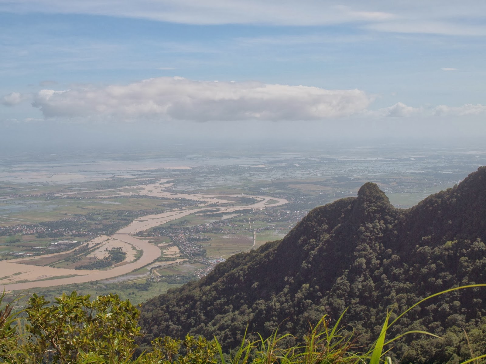
View from North Peak (West)
View from North Peak (South West)
Resting at the hut
Family picture with strong boys
Breathtaking view
The radio tower station
- 13:20 This was the start of our catwalk maneuver going to South Peak. The trail was narrow and both sides of it were cliffs. We were very careful during the traverse especially since it was Justine's 1st climb and our 1st traverse ever as climbers, we don't want any bad memories.
The first light challenge of the traverse
The Catwalk
A marker to signal that we are still on track
What sorcery is this?!
Justine being very careful on our traverse
Boulder photo ops (Not part of the trail)
Tree climb photo ops (Not again part of the trail)
At the rocky detour
Boulders held by roots
Emo post
- 16:00 We were getting nervous when we haven't reached South Peak and the sky was giving signs of sunset. We hastened our pace to reach South Peak before sunset and decide if it was still safe to descend.
Desecrating the beautiful rock formation
Braveheart Stance
View from the rock (East)
View from the rock (West)
View from the rock (North)
The steep 75.50 degree traverse
Engle praying before the descend
The narrow path around the big rock formation
I got curious with this branch
Another catwalk
The Rock
An eagle looking for some prey
The last ascend before the South Peak
The grassy South Peak
- 17:45 We reached the South Peak and did some photo ops before sunset. We called it as a failed day hike traverse, and to pay for our incompetence we will spend the cold night at the edge of South Peak. We have no ration for dinner and no thermal clothing, we conserved what was left of our water and energy bars for tomorrows descend. The sleep on top of Mt. Arayat has got to be one of the most craziest thing we did. No planning, no preparation, no supplies. Just ample supply of jokes and topics to keep us sane up to the first sunrise.
Camp site at South Peak
A little sunshine before the dark
Posing for the photo ops area at South Peak
The Pampanga Skyline with 2 stooges preparing to rest
- 00:00 Sleeping on the cold soil with mountain dew and strong winds was no joke, it was far colder here than at Baguio City at night. But we enjoyed looking at constellations, shooting stars, passing planes, and some unidentified flying objects we can't classify but we bet those were satellites orbiting Earth (feeling 20th Century Boys)
- 06:00 As was expected of the 3 stooges, we managed to stay alive for 12 hours. The 1st heat of that sunrise must have been one of the best feeling we had experience. After an hour of defrosting our body and refilling our tummies with a few marshmallows and water, we started back tracking until we reached the camping site. Turns out the area where we slept was a dead end going to the signature photo ops area of Mt. Arayat.
The first rays of sunshine!
Goodmorning Justine the Mermaid
The narrow strip where we slept. Both sides are deep cliffs
The ultimate photo ops area of Mt. Arayat, you can stand on that small area
Look for the radio tower, and tha rock is a fine sight
The way going down to the posing area for the South Peak photo ops
The 1st part of the trail down was leafy and the trail was pretty wide
We were nervous to cross these rocks, looks like it could collapse any time
The middle part of the descend was rocky
A natural viewing deck along the trail
These big rocks made the descend exciting
A wild lizard we passed along the way
KM 93 marks the end of the trail
- 10:00 touch down at Forest Ranger's Station at San Juan Baño, Arayat, Pampanga. We didn't encounter any tricycles parked so we walked until we arrived at a nearby store. We ate what's got to be one of the tastiest cup noodles we ever ate! Along with the most refreshing cold soft drinks. The kind people at the store offered us a ride for just 150.00 php because one of them will be going out to go to Bayan (Common term used for town proper). We told the driver to take us to Kabigting's, for their famous Halo2x.
Forest Ranger's Station
A local church that I didn't got the name
Rocks from the landslide placed beside the road to may some way
Clean Up Drive
Arayat's Glorietta
The South Peak, with some landslides
- 11:20 Touchdown at Kabigting's! Their Halo2x only has a handful of ingredients but it's got to be one of the most delicious Halo2x rendition I've tasted, truly a pride of Arayat. After having lunch at Kabigting's we rode a tricycle for 35.00 php to take us to DJ's Bus Terminal, the bus ticket going back to Monumento was 125.00 php each.
Kabigting's
Kabigting's Halo-Halo, the pride of Arayat
Interior design of Kabigting's
- 14:30 Touchdown Manila!